
Carte topographique La Rochelle
Carte interactive
Cliquez sur la carte pour afficher l’altitude.
À propos de cette carte
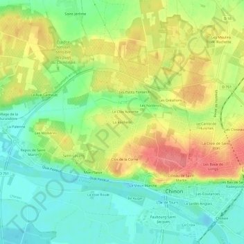
Nom : Carte topographique La Rochelle, altitude, relief.
Altitude moyenne : 58 m
Altitude minimum : 24 m
Altitude maximum : 103 m
Autres cartes topographiques
Cliquez sur une carte pour visualiser sa topographie, son altitude et son relief.
La Ville
France > Centre-Val de Loire > Indre-et-Loire > Chinon > La Ville
La Ville, Chinon, Indre-et-Loire, Centre-Val de Loire, France métropolitaine, 37500, France
Altitude moyenne : 52 m
Le Jardin Anglais
France > Centre-Val de Loire > Indre-et-Loire > Chinon
Le Jardin Anglais, Chinon, Indre-et-Loire, Centre-Val de Loire, France métropolitaine, 37500, France
Altitude moyenne : 52 m
Saint-Jean
France > Centre-Val de Loire > Indre-et-Loire > Chinon
Saint-Jean, Chinon, Indre-et-Loire, Centre-Val de Loire, France métropolitaine, 37500, France
Altitude moyenne : 59 m
Mon Plaisir
France > Centre-Val de Loire > Indre-et-Loire > Chinon
Mon Plaisir, Chinon, Indre-et-Loire, Centre-Val de Loire, France métropolitaine, 37500, France
Altitude moyenne : 50 m
L'Île de Tours
France > Centre-Val de Loire > Indre-et-Loire > Chinon
L'Île de Tours, Chinon, Indre-et-Loire, Centre-Val de Loire, France métropolitaine, 37500, France
Altitude moyenne : 51 m
Les Courances
France > Centre-Val de Loire > Indre-et-Loire > Chinon
Les Courances, Chinon, Indre-et-Loire, Centre-Val de Loire, France métropolitaine, 37500, France
Altitude moyenne : 54 m
La Croix de Saint-Jean
France > Centre-Val de Loire > Indre-et-Loire > Chinon
La Croix de Saint-Jean, Chinon, Indre-et-Loire, Centre-Val de Loire, France métropolitaine, 37500, France
Altitude moyenne : 62 m
La Ville
France > Centre-Val de Loire > Indre-et-Loire > Chinon
La Ville, Chinon, Indre-et-Loire, Centre-Val de Loire, France métropolitaine, 37500, France
Altitude moyenne : 53 m
Les Hucherolles
France > Centre-Val de Loire > Indre-et-Loire > Chinon > Les Hucherolles
Les Hucherolles, Chinon, Indre-et-Loire, Centre-Val de Loire, France métropolitaine, 37500, France
Altitude moyenne : 57 m
Les Ganaudières
France > Centre-Val de Loire > Indre-et-Loire > Chinon > Les Ganaudières
Les Ganaudières, Chinon, Indre-et-Loire, Centre-Val de Loire, France métropolitaine, 37500, France
Altitude moyenne : 61 m
Le Vieux Marché
France > Centre-Val de Loire > Indre-et-Loire > Chinon
Le Vieux Marché, Chinon, Indre-et-Loire, Centre-Val de Loire, France métropolitaine, 37500, France
Altitude moyenne : 51 m
Le Bois de la Grille
France > Centre-Val de Loire > Indre-et-Loire > Chinon > Le Villier
Le Bois de la Grille, Le Villier, Chinon, Indre-et-Loire, Centre-Val de Loire, France métropolitaine, 37500, France
Altitude moyenne : 75 m
Coteau de Saint-Martin
France > Centre-Val de Loire > Indre-et-Loire > Chinon
Coteau de Saint-Martin, Chinon, Indre-et-Loire, Centre-Val de Loire, France métropolitaine, 37500, France
Altitude moyenne : 55 m
La Croix
France > Centre-Val de Loire > Indre-et-Loire > Chinon > La Croix
La Croix, Chinon, Indre-et-Loire, Centre-Val de Loire, France métropolitaine, 37500, France
Altitude moyenne : 51 m
Les Grésillons
France > Centre-Val de Loire > Indre-et-Loire > Chinon
Les Grésillons, Chinon, Indre-et-Loire, Centre-Val de Loire, France métropolitaine, 37500, France
Altitude moyenne : 64 m
Faubourg Saint-Jacques
France > Centre-Val de Loire > Indre-et-Loire > Chinon
Faubourg Saint-Jacques, Chinon, Indre-et-Loire, Centre-Val de Loire, France métropolitaine, 37500, France
Altitude moyenne : 50 m