
Carte topographique Untermuehlthal
Carte interactive
Cliquez sur la carte pour afficher l’altitude.
À propos de cette carte
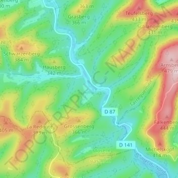
Nom : Carte topographique Untermuehlthal, altitude, relief.
Altitude moyenne : 290 m
Altitude minimum : 188 m
Altitude maximum : 476 m
Autres cartes topographiques
Cliquez sur une carte pour visualiser sa topographie, son altitude et son relief.
Ramstein
France > Grand Est > Moselle > Baerenthal
Ramstein, Baerenthal, Sarreguemines, Moselle, Grand Est, France métropolitaine, 57230, France
Altitude moyenne : 265 m