
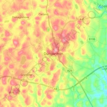
Carte topographique Dungannon
Carte interactive
Cliquez sur la carte pour afficher l’altitude.
À propos de cette carte
Nom : Carte topographique Dungannon, altitude, relief.
Altitude moyenne : 76 m
Altitude minimum : 15 m
Altitude maximum : 132 m
Autres cartes topographiques
Cliquez sur une carte pour visualiser sa topographie, son altitude et son relief.
Clady
United Kingdom > Northern Ireland > County Tyrone
Clady, County Tyrone, Northern Ireland, BT82 9QY, United Kingdom
Altitude moyenne : 46 m
Stewartstown
United Kingdom > Northern Ireland > County Tyrone
Stewartstown, County Tyrone, Northern Ireland, BT71 5JE, United Kingdom
Altitude moyenne : 76 m
Strabane
United Kingdom > Northern Ireland > County Tyrone
Strabane, County Tyrone, Northern Ireland, BT82 8AH, United Kingdom
Altitude moyenne : 71 m
Cappagh
United Kingdom > Northern Ireland > County Tyrone
Cappagh, County Tyrone, Northern Ireland, United Kingdom
Altitude moyenne : 234 m
Donaghmore
United Kingdom > Northern Ireland > County Tyrone
Donaghmore, County Tyrone, Northern Ireland, BT70 3HB, United Kingdom
Altitude moyenne : 88 m
Esker Hill
United Kingdom > Northern Ireland > County Tyrone
Esker Hill, County Tyrone, Northern Ireland, BT70 3AW, United Kingdom
Altitude moyenne : 185 m
Augher
United Kingdom > Northern Ireland > County Tyrone
Augher, County Tyrone, Northern Ireland, BT77 0BG, United Kingdom
Altitude moyenne : 73 m
Dromore
United Kingdom > Northern Ireland > County Tyrone
Dromore, County Tyrone, Northern Ireland, BT78 3GA, United Kingdom
Altitude moyenne : 113 m
Coagh
United Kingdom > Northern Ireland > County Tyrone
Coagh, County Tyrone, Northern Ireland, BT80 0EF, United Kingdom
Altitude moyenne : 43 m
Bready
United Kingdom > Northern Ireland > County Tyrone
Bready, County Tyrone, Northern Ireland, BT82 0ED, United Kingdom
Altitude moyenne : 36 m
Clonoe
United Kingdom > Northern Ireland > County Tyrone > Coalisland
Clonoe, Coalisland, County Tyrone, Ulster, Northern Ireland, United Kingdom
Altitude moyenne : 32 m
Coalisland
United Kingdom > Northern Ireland > County Tyrone
Coalisland, County Tyrone, Ulster, Northern Ireland, BT71 4NB, United Kingdom
Altitude moyenne : 59 m
Gortin
United Kingdom > Northern Ireland > County Tyrone
Gortin, County Tyrone, Ulster, Northern Ireland, BT79 8NH, United Kingdom
Altitude moyenne : 162 m
Mullaghcarn
United Kingdom > Northern Ireland > County Tyrone
Mullaghcarn, County Tyrone, Ulster, Northern Ireland, BT79 8PU, United Kingdom
Altitude moyenne : 386 m
Cookstown
United Kingdom > Northern Ireland > County Tyrone
Cookstown, County Tyrone, Northern Ireland, BT80 8PF, United Kingdom
Altitude moyenne : 67 m
Ballygawley
United Kingdom > Northern Ireland > County Tyrone
Ballygawley, County Tyrone, Northern Ireland, BT70 2HB, United Kingdom
Altitude moyenne : 104 m
Newmills
United Kingdom > Northern Ireland > County Tyrone
Newmills, County Tyrone, Ulster, Northern Ireland, BT71 4DX, United Kingdom
Altitude moyenne : 77 m
Owenreagh
United Kingdom > Northern Ireland > County Tyrone
Owenreagh, County Tyrone, Ulster, Northern Ireland, United Kingdom
Altitude moyenne : 142 m
Fivemiletown
United Kingdom > Northern Ireland > County Tyrone
Fivemiletown, County Tyrone, Northern Ireland, BT75 0RX, United Kingdom
Altitude moyenne : 103 m
Ardstraw
United Kingdom > Northern Ireland > County Tyrone
Ardstraw, County Tyrone, Ulster, Northern Ireland, BT78 4LA, United Kingdom
Altitude moyenne : 71 m
Kildress
United Kingdom > Northern Ireland > County Tyrone > Oritor
Kildress, Oritor, County Tyrone, Ulster, Northern Ireland, United Kingdom
Altitude moyenne : 174 m
Craig
United Kingdom > Northern Ireland > County Tyrone
Craig, County Tyrone, Ulster, Northern Ireland, United Kingdom
Altitude moyenne : 231 m
Creggan
United Kingdom > Northern Ireland > County Tyrone
Creggan, County Tyrone, Ulster, Northern Ireland, BT79 9AF, United Kingdom
Altitude moyenne : 190 m
Drumskinny
United Kingdom > Northern Ireland > County Tyrone
Drumskinny, County Tyrone, Ulster, Northern Ireland, United Kingdom
Altitude moyenne : 121 m
Curraghinalt
United Kingdom > Northern Ireland > County Tyrone
Curraghinalt, County Tyrone, Ulster, Northern Ireland, United Kingdom
Altitude moyenne : 229 m
Owenreagh
United Kingdom > Northern Ireland > County Tyrone
Owenreagh, County Tyrone, Northern Ireland, BT78 5BR, United Kingdom
Altitude moyenne : 96 m
Artigarvan
United Kingdom > Northern Ireland > County Tyrone
Artigarvan, County Tyrone, Northern Ireland, BT82 0HN, United Kingdom
Altitude moyenne : 74 m
Killymoon River
United Kingdom > Northern Ireland > County Tyrone
Killymoon River, County Tyrone, Ulster, Northern Ireland, BT71 4DA, United Kingdom
Altitude moyenne : 86 m
Ardboe
United Kingdom > Northern Ireland > County Tyrone
Ardboe, County Tyrone, Northern Ireland, BT80 0HT, United Kingdom
Altitude moyenne : 16 m
Moortown
United Kingdom > Northern Ireland > County Tyrone
Moortown, County Tyrone, Northern Ireland, BT80 0HT, United Kingdom
Altitude moyenne : 19 m
Laghey
United Kingdom > Northern Ireland > County Tyrone
Laghey, County Tyrone, Ulster, Northern Ireland, BT71 6RJ, United Kingdom
Altitude moyenne : 36 m
Eskragh
United Kingdom > Northern Ireland > County Tyrone
Eskragh, County Tyrone, Ulster, Northern Ireland, United Kingdom
Altitude moyenne : 119 m
Mourne
United Kingdom > Northern Ireland > County Tyrone > Strabane
Mourne, Strabane, County Tyrone, Ulster, Northern Ireland, BT82 8AE, United Kingdom
Altitude moyenne : 97 m
Benburb
United Kingdom > Northern Ireland > County Tyrone
Benburb, County Tyrone, Northern Ireland, BT71 7JZ, United Kingdom
Altitude moyenne : 45 m
Fintona
United Kingdom > Northern Ireland > County Tyrone
Fintona, County Tyrone, Ulster, Northern Ireland, BT78 2AS, United Kingdom
Altitude moyenne : 118 m
Moy
United Kingdom > Northern Ireland > County Tyrone
Moy, County Tyrone, Northern Ireland, BT71 7SG, United Kingdom
Altitude moyenne : 26 m
Trillick
United Kingdom > Northern Ireland > County Tyrone
Trillick, County Tyrone, Ulster, Northern Ireland, BT78 3RB, United Kingdom
Altitude moyenne : 130 m
New Buildings
United Kingdom > Northern Ireland > County Tyrone > Cookstown
New Buildings, Cookstown, County Tyrone, Northern Ireland, United Kingdom
Altitude moyenne : 66 m
Plumbridge
United Kingdom > Northern Ireland > County Tyrone
Plumbridge, County Tyrone, Ulster, Northern Ireland, BT79 8AA, United Kingdom
Altitude moyenne : 171 m
Castlederg
United Kingdom > Northern Ireland > County Tyrone
Castlederg, County Tyrone, Northern Ireland, BT81 7AR, United Kingdom
Altitude moyenne : 78 m
Drumquin
United Kingdom > Northern Ireland > County Tyrone
Drumquin, County Tyrone, Northern Ireland, BT78 4SB, United Kingdom
Altitude moyenne : 97 m
Carrickmore
United Kingdom > Northern Ireland > County Tyrone
Carrickmore, County Tyrone, Ulster, Northern Ireland, BT79 9BE, United Kingdom
Altitude moyenne : 146 m
Mountfield
United Kingdom > Northern Ireland > County Tyrone > Mountfield
Mountfield, County Tyrone, Ulster, Northern Ireland, BT79 7PT, United Kingdom
Altitude moyenne : 217 m
Sixmilecross
United Kingdom > Northern Ireland > County Tyrone
Sixmilecross, County Tyrone, Ulster, Northern Ireland, BT79 9DH, United Kingdom
Altitude moyenne : 121 m
Sawel
United Kingdom > Northern Ireland > County Tyrone
Sawel, County Tyrone, Ulster, Northern Ireland, United Kingdom
Altitude moyenne : 439 m
Douglas Bridge
United Kingdom > Northern Ireland > County Tyrone
Douglas Bridge, County Tyrone, Ulster, Northern Ireland, BT78 4JZ, United Kingdom
Altitude moyenne : 76 m
Mount Hamilton
United Kingdom > Northern Ireland > County Tyrone
Mount Hamilton, County Tyrone, Ulster, Northern Ireland, United Kingdom
Altitude moyenne : 266 m