
Carte topographique Erfurt
Carte interactive
Cliquez sur la carte pour afficher l’altitude.
À propos de cette carte
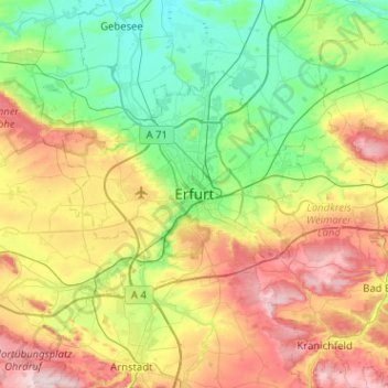
Nom : Carte topographique Erfurt, altitude, relief.
Lieu : Erfurt, Thuringia, 99084, Germany (50.81780 10.86874 51.13780 11.18874)
Altitude moyenne : 272 m
Altitude minimum : 143 m
Altitude maximum : 511 m
Erfurt is situated in the south of the Thuringian basin, a fertile agricultural area between the Harz mountains 80 km (50 mi) to the north and the Thuringian forest 30 km (19 mi) to the southwest. Whereas the northern parts of the city area are flat, the southern ones consist of hilly landscape up to 430 m of elevation. In this part lies the municipal forest of Steigerwald with beeches and oaks as main tree species. To the east and to the west are some non-forested hills so that the Gera river valley within the town forms a basin. North of the city are some gravel pits in operation, while others are abandoned, flooded and used as leisure areas.