
Carte topographique Adana
Carte interactive
Cliquez sur la carte pour afficher l’altitude.
À propos de cette carte
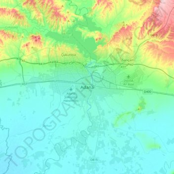
Nom : Carte topographique Adana, altitude, relief.
Lieu : Adana, Seyhan, Adana, Mediterranean Region, 01010, Turkey (36.82636 35.16529 37.14636 35.48529)
Altitude moyenne : 61 m
Altitude minimum : 3 m
Altitude maximum : 312 m
Adana is located on the 37th parallel north on the northeastern edge of the Mediterranean, where it serves as the gateway to the Cilician plain. This large stretch of flat, fertile land lies southeast of the Taurus Mountains. Heading west across Cilicia from Adana, the road from Tarsus enters the foothills of the Taurus Mountains, eventually reaching an altitude of nearly 4,000 feet (1,200 m). It passes through the famous Cilician Gates, a rocky pass through which countless armies have travelled and continues north to the Anatolian plain.