
Carte topographique Inman Valley
Carte interactive
Cliquez sur la carte pour afficher l’altitude.
À propos de cette carte
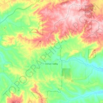
Nom : Carte topographique Inman Valley, altitude, relief.
Altitude moyenne : 212 m
Altitude minimum : 49 m
Altitude maximum : 443 m
In the valley is Selwyn Rock (35°29′47″S 138°30′45″E / 35.4965°S 138.5124°E / -35.4965; 138.5124) a glaciated pavement in the bed of the Inman River. It was first described in 1859 by, and later named for, A.R.C. Selwyn,[17] who was Victorian Government geologist at the time. Glacial grooves and striations on the polished surface indicate glacial movement to the north-west. Boulder clays, tillites and erratics are also common in the area, which underwent glaciation during the Permian (approximately 270 Ma). The pavement was exposed during the Tertiary when the Inman River eroded the topography to its present-day surface. A cafe overlooks the glaciated bed of the river, with access onto the rock available via stairs and viewing platforms.
Autres cartes topographiques
Cliquez sur une carte pour visualiser sa topographie, son altitude et son relief.
Bald Hills
Australia > South Australia > The District Council of Yankalilla
Bald Hills, The District Council of Yankalilla, South Australia, 5203, Australia
Altitude moyenne : 162 m
Myponga Beach
Australia > South Australia > The District Council of Yankalilla
Myponga Beach, The District Council of Yankalilla, South Australia, 5202, Australia
Altitude moyenne : 110 m
Kalumunda Forest Reserve
Australia > South Australia > The District Council of Yankalilla
Kalumunda Forest Reserve, Hay Flat, The District Council of Yankalilla, South Australia, 5204, Australia
Altitude moyenne : 265 m
Deep Creek Conservation Park
Australia > South Australia > The District Council of Yankalilla
Deep Creek Conservation Park, Deep Creek, The District Council of Yankalilla, South Australia, 5204, Australia
Altitude moyenne : 183 m
Yankalilla
Australia > South Australia > The District Council of Yankalilla
Yankalilla, The District Council of Yankalilla, South Australia, 5203, Australia
Altitude moyenne : 104 m
Myponga River
Australia > South Australia > The District Council of Yankalilla > Myponga > Myponga Beach
Myponga River, Myponga Beach, Myponga, The District Council of Yankalilla, South Australia, 5202, Australia
Altitude moyenne : 138 m
Myponga
Australia > South Australia > The District Council of Yankalilla
Myponga, The District Council of Yankalilla, South Australia, 5202, Australia
Altitude moyenne : 246 m
Second Valley
Australia > South Australia > The District Council of Yankalilla
Second Valley, The District Council of Yankalilla, South Australia, 5204, Australia
Altitude moyenne : 173 m
Normanville
Australia > South Australia > The District Council of Yankalilla
Normanville, The District Council of Yankalilla, South Australia, 5204, Australia
Altitude moyenne : 64 m
Carrickalinga
Australia > South Australia > The District Council of Yankalilla
Carrickalinga, The District Council of Yankalilla, South Australia, 5204, Australia
Altitude moyenne : 53 m
Rapid Bay
Australia > South Australia > The District Council of Yankalilla
Rapid Bay, The District Council of Yankalilla, South Australia, 5204, Australia
Altitude moyenne : 104 m
Cape Jervis
Australia > South Australia > The District Council of Yankalilla
Cape Jervis, The District Council of Yankalilla, South Australia, 5204, Australia
Altitude moyenne : 73 m
Wirrina Cove
Australia > South Australia > The District Council of Yankalilla
Wirrina Cove, The District Council of Yankalilla, South Australia, 5204, Australia
Altitude moyenne : 43 m