
Carte topographique Latacunga
Carte interactive
Cliquez sur la carte pour afficher l’altitude.
À propos de cette carte
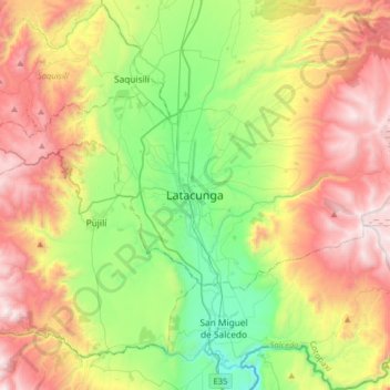
Nom : Carte topographique Latacunga, altitude, relief.
Lieu : Latacunga, Cotopaxi, 0501, Équateur (-1.09403 -78.77458 -0.77403 -78.45458)
Altitude moyenne : 3 213 m
Altitude minimum : 2 526 m
Altitude maximum : 4 165 m
Autres cartes topographiques
Cliquez sur une carte pour visualiser sa topographie, son altitude et son relief.
San Fransisco
Équateur > Cotopaxi > Latacunga > Latacunga
San Fransisco, Eloy Alfaro, Latacunga, Cotopaxi, 050105, Équateur
Altitude moyenne : 2 887 m