
Carte topographique Letterkenny
Carte interactive
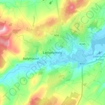
Cliquez sur la carte pour afficher l’altitude.
À propos de cette carte
Nom : Carte topographique Letterkenny, altitude, relief.
Altitude moyenne : 93 m
Altitude minimum : -4 m
Altitude maximum : 289 m
Autres cartes topographiques
Cliquez sur une carte pour visualiser sa topographie, son altitude et son relief.
Carn Hill
Ireland > County Donegal > Letterkenny
Carn Hill, Letterkenny, County Donegal, F92 W8CY, Ireland
Altitude moyenne : 144 m
Lisnenan
Ireland > County Donegal > Letterkenny
Lisnenan, Letterkenny Rural ED, Letterkenny, County Donegal, F92 W8CY, Ireland
Altitude moyenne : 101 m
Glencar Scotch
Ireland > County Donegal > Letterkenny
Glencar Scotch, Letterkenny Rural ED, Letterkenny, County Donegal, Ireland
Altitude moyenne : 134 m
Glen Lough
Ireland > County Donegal > Letterkenny
Glen Lough, Millford ED, Letterkenny, County Donegal, Ulster, Ireland
Altitude moyenne : 89 m
Stragraddy
Ireland > County Donegal > Letterkenny
Stragraddy, Termon ED, Letterkenny, County Donegal, Ulster, Ireland
Altitude moyenne : 118 m
Church Hill
Ireland > County Donegal > Letterkenny
Church Hill, Church Hill ED, Letterkenny, County Donegal, Ireland
Altitude moyenne : 117 m
Bomany
Ireland > County Donegal > Letterkenny
Bomany, Ballymacool ED, Letterkenny, County Donegal, Ulster, Ireland
Altitude moyenne : 62 m
Sallaghagrane
Ireland > County Donegal > Letterkenny
Sallaghagrane, Letterkenny Rural ED, Letterkenny, County Donegal, Ulster, Ireland
Altitude moyenne : 57 m
Melmore Head
Ireland > County Donegal > Letterkenny
Melmore Head, Atlantic Way, Rosguill ED, Letterkenny, County Donegal, Ireland
Altitude moyenne : 9 m
Crockdonnelly
Ireland > County Donegal > Letterkenny
Crockdonnelly, Fanad North ED, Letterkenny, County Donegal, F92 NN88, Ireland
Altitude moyenne : 51 m
Loughros Glebe
Ireland > County Donegal > Letterkenny
Loughros Glebe, Glenalla ED, Letterkenny, County Donegal, Ireland
Altitude moyenne : 79 m