
Carte topographique Magnolia
Carte interactive
Cliquez sur la carte pour afficher l’altitude.
À propos de cette carte
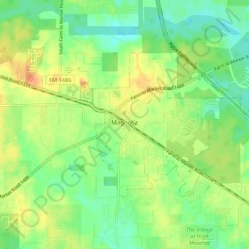
Nom : Carte topographique Magnolia, altitude, relief.
Lieu : Magnolia, Montgomery County, Texas, United States (30.18961 -95.77650 30.22826 -95.69937)
Altitude moyenne : 77 m
Altitude minimum : 58 m
Altitude maximum : 102 m
Autres cartes topographiques
Cliquez sur une carte pour visualiser sa topographie, son altitude et son relief.
Conroe
United States > Texas > Montgomery County
Conroe, Montgomery County, Texas, United States
Altitude moyenne : 62 m
Karen
United States > Texas > Montgomery County
Karen, Montgomery County, Texas, United States
Altitude moyenne : 67 m
Grangerland
United States > Texas > Montgomery County
Grangerland, Montgomery County, Texas, 77306, United States
Altitude moyenne : 46 m
Willis
United States > Texas > Montgomery County
Willis, Montgomery County, Texas, 77305, United States
Altitude moyenne : 99 m
River Plantation
United States > Texas > Montgomery County
River Plantation, Montgomery County, Texas, United States
Altitude moyenne : 43 m
The Woodlands
United States > Texas > Montgomery County
The Woodlands, Montgomery County, Texas, United States
Altitude moyenne : 47 m
Lake Conroe
United States > Texas > Montgomery County > Conroe
Lake Conroe, Conroe, Montgomery County, Texas, 77356, United States
Altitude moyenne : 84 m
Woodbranch
United States > Texas > Montgomery County
Woodbranch, Montgomery County, Texas, United States
Altitude moyenne : 31 m
Security
United States > Texas > Montgomery County
Security, Montgomery County, Texas, United States
Altitude moyenne : 53 m
Porter
United States > Texas > Montgomery County
Porter, Montgomery County, Texas, 77365, United States
Altitude moyenne : 30 m
New Caney
United States > Texas > Montgomery County
New Caney, Montgomery County, Texas, 77357, United States
Altitude moyenne : 30 m
Splendora
United States > Texas > Montgomery County
Splendora, Montgomery County, Texas, 77372, United States
Altitude moyenne : 37 m
Indian Springs
United States > Texas > Montgomery County > The Woodlands
Indian Springs, The Woodlands, Montgomery County, Texas, United States
Altitude moyenne : 48 m
Mill Creek
United States > Texas > Montgomery County
Mill Creek, Montgomery County, Texas, 77354, United States
Altitude moyenne : 56 m
Patton Village
United States > Texas > Montgomery County
Patton Village, Montgomery County, Texas, United States
Altitude moyenne : 33 m
Oakhurst
United States > Texas > Montgomery County
Oakhurst, Montgomery County, Texas, 77365, United States
Altitude moyenne : 28 m
Egypt
United States > Texas > Montgomery County
Egypt, Montgomery County, Texas, 77382, United States
Altitude moyenne : 63 m
Conroe
United States > Texas > Montgomery County > Conroe > Conroe
Conroe, Montgomery County, Texas, 77301, United States
Altitude moyenne : 60 m
College Park
United States > Texas > Montgomery County > The Woodlands
College Park, The Woodlands, Montgomery County, Texas, United States
Altitude moyenne : 47 m
Willis
United States > Texas > Montgomery County > Willis > Willis
Willis, Montgomery County, Texas, 77305, United States
Altitude moyenne : 98 m
Pittsville
United States > Texas > Montgomery County > Pittsville
Pittsville, Montgomery County, Texas, 77339-1510, United States
Altitude moyenne : 27 m
Shenandoah
United States > Texas > Montgomery County
Shenandoah, Montgomery County, Texas, United States
Altitude moyenne : 44 m
Alden Bridge
United States > Texas > Montgomery County > The Woodlands
Alden Bridge, The Woodlands, Montgomery County, Texas, 77382, United States
Altitude moyenne : 55 m
Grogan's Mill
United States > Texas > Montgomery County > The Woodlands
Grogan's Mill, The Woodlands, Montgomery County, Texas, 77380, United States
Altitude moyenne : 40 m
Oak Ridge North
United States > Texas > Montgomery County
Oak Ridge North, Montgomery County, Texas, United States
Altitude moyenne : 44 m
Porter Heights
United States > Texas > Montgomery County
Porter Heights, Montgomery County, Texas, United States
Altitude moyenne : 37 m