
Carte topographique Barrington
Carte interactive
Cliquez sur la carte pour afficher l’altitude.
À propos de cette carte
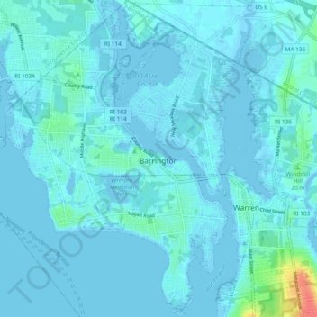
Nom : Carte topographique Barrington, altitude, relief.
Altitude moyenne : 4 m
Altitude minimum : -7 m
Altitude maximum : 47 m
Barrington lies on a low, mostly flat plain bordering the sea. This plain, composed mostly of layers of clay, gravel, sand, and silt soils, was formed by a melting glacier towards the end of the last ice age. Bedrock underlying the soil is largely composed of shales, sandstone, and conglomerate rock, with some outcrops of quartz. A few extremes in elevation, such as Nayatt Point, Primrose and Prince's Hill, rise to heights of fifty feet.
Autres cartes topographiques
Cliquez sur une carte pour visualiser sa topographie, son altitude et son relief.
Bristol
United States > Rhode Island > Bristol County
Bristol, Bristol County, Rhode Island, 02809, United States
Altitude moyenne : 6 m
Warren
United States > Rhode Island > Bristol County
Warren, Bristol County, Rhode Island, 02885, United States
Altitude moyenne : 6 m