
Carte topographique London Borough of Bexley
Carte interactive
Cliquez sur la carte pour afficher l’altitude.
À propos de cette carte
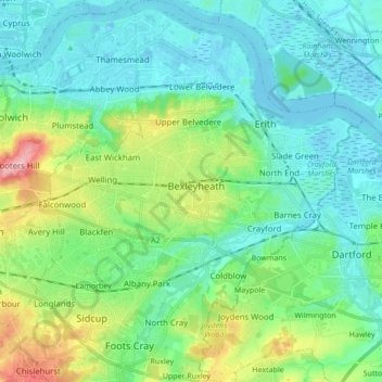
Nom : Carte topographique London Borough of Bexley, altitude, relief.
Altitude moyenne : 31 m
Altitude minimum : -7 m
Altitude maximum : 130 m
Autres cartes topographiques
Cliquez sur une carte pour visualiser sa topographie, son altitude et son relief.
Ruxley
United Kingdom > England > Greater London > London Borough of Bexley > Ruxley
Ruxley, London Borough of Bexley, Greater London, England, DA14 5BE, United Kingdom
Altitude moyenne : 49 m