
Carte topographique Galgenberg
Carte interactive
Cliquez sur la carte pour afficher l’altitude.
À propos de cette carte
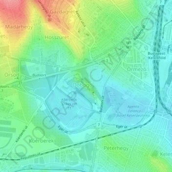
Nom : Carte topographique Galgenberg, altitude, relief.
Lieu : Galgenberg, XI. Bezirk, Budapest, Mittelungarn, Ungarn (47.45428 18.99758 47.46251 19.00855)
Altitude moyenne : 130 m
Altitude minimum : 104 m
Altitude maximum : 196 m
Autres cartes topographiques
Cliquez sur une carte pour visualiser sa topographie, son altitude et son relief.
Gellértberg
Gellértberg, Budapest, XI. Bezirk, Mittelungarn, 1114, Ungarn
Altitude moyenne : 126 m
Gottesberg
Gottesberg, XII. Bezirk, Budapest, XII. Bezirk, Mittelungarn, 1125, Ungarn
Altitude moyenne : 247 m
Johannisberg
Johannisberg, XII. Bezirk, Budapest, Mittelungarn, 1021, Ungarn
Altitude moyenne : 343 m
Johannisberg
Johannisberg, XII. Bezirk, Budapest, Mittelungarn, Ungarn
Altitude moyenne : 333 m