
Carte topographique Poulton
Carte interactive
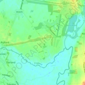
Cliquez sur la carte pour afficher l’altitude.
À propos de cette carte
Nom : Carte topographique Poulton, altitude, relief.
Altitude moyenne : 14 m
Altitude minimum : 4 m
Altitude maximum : 37 m
Autres cartes topographiques
Cliquez sur une carte pour visualiser sa topographie, son altitude et son relief.
Countess of Chester Country Park
United Kingdom > England > Cheshire West and Chester > Chester
Countess of Chester Country Park, Upton-by-Chester, Chester, Cheshire West and Chester, England, CH1 4BE, United Kingdom
Altitude moyenne : 21 m
Roman Fort
United Kingdom > England > Cheshire West and Chester > Chester
Roman Fort, Sandy Lane, Caldy Valley, Huntington, Chester, Cheshire West and Chester, North West England, England, CH3 6GS, United Kingdom
Altitude moyenne : 21 m
Chester Castle
United Kingdom > England > Cheshire West and Chester > Chester
Chester Castle, City Walls, Chester Castle, Chester, Cheshire West and Chester, North West England, England, CH1 1SG, United Kingdom
Altitude moyenne : 18 m