
Carte topographique Cheshire County
Carte interactive
Cliquez sur la carte pour afficher l’altitude.
À propos de cette carte
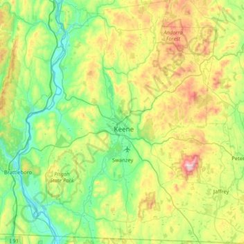
Nom : Carte topographique Cheshire County, altitude, relief.
Lieu : Cheshire County, New Hampshire, United States (42.71216 -72.55724 43.18196 -71.92886)
Altitude moyenne : 308 m
Altitude minimum : 54 m
Altitude maximum : 944 m
Autres cartes topographiques
Cliquez sur une carte pour visualiser sa topographie, son altitude et son relief.
Dover
United States > New Hampshire > Strafford County
Dover, Strafford County, New Hampshire, 03820, United States
Altitude moyenne : 31 m
Jaffrey
United States > New Hampshire > Cheshire County
Jaffrey, Cheshire County, New Hampshire, 03452, United States
Altitude moyenne : 351 m
Atkinson
United States > New Hampshire > Rockingham County
Atkinson, Rockingham County, New Hampshire, 03811, United States
Altitude moyenne : 63 m
Laconia
United States > New Hampshire > Belknap County
Laconia, Belknap County, New Hampshire, United States
Altitude moyenne : 203 m
Tuftonboro
United States > New Hampshire > Tuftonboro
Tuftonboro, Carroll County, New Hampshire, United States
Altitude moyenne : 256 m
Hudson
United States > New Hampshire > Hudson
Hudson, Hillsborough County, New Hampshire, 03051, United States
Altitude moyenne : 68 m
Exeter
United States > New Hampshire > Exeter
Exeter, Rockingham County, New Hampshire, United States
Altitude moyenne : 24 m
Durham
United States > New Hampshire > Durham
Durham, Strafford County, New Hampshire, 03824, United States
Altitude moyenne : 23 m
Manchester
United States > New Hampshire > Hillsborough County
Manchester, Hillsborough County, New Hampshire, United States
Altitude moyenne : 96 m
Grafton County
Grafton County, New Hampshire, United States
Altitude moyenne : 424 m