
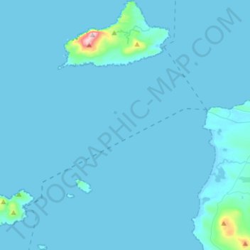
Carte topographique Clare Island ED
Carte interactive
Cliquez sur la carte pour afficher l’altitude.
À propos de cette carte
Nom : Carte topographique Clare Island ED, altitude, relief.
Altitude moyenne : 12 m
Altitude minimum : -2 m
Altitude maximum : 456 m
Autres cartes topographiques
Cliquez sur une carte pour visualiser sa topographie, son altitude et son relief.
Westport-Belmullet Municipal District
Westport-Belmullet Municipal District, County Mayo, Connacht, Irlande
Altitude moyenne : 62 m
Clare Island
Clare Island, Westport-Belmullet Municipal District, County Mayo, Connacht, Irlande
Altitude moyenne : 29 m
Belmullet
Belmullet, Belmullet ED, Westport-Belmullet Municipal District, County Mayo, Connacht, Irlande
Altitude moyenne : 7 m
Glenagh
Glenagh, Béal Deirg Mór ED, Westport-Belmullet Municipal District, County Mayo, Connacht, Irlande
Altitude moyenne : 208 m
Aille River
Aille River, Aghagower South ED, Westport-Belmullet Municipal District, County Mayo, Connacht, Irlande
Altitude moyenne : 83 m
Owennadornaun ED
Owennadornaun ED, Westport-Belmullet Municipal District, County Mayo, Connacht, Irlande
Altitude moyenne : 157 m
Aille River
Aille River, Aghagower South ED, Westport-Belmullet Municipal District, County Mayo, Connacht, Irlande
Altitude moyenne : 65 m
Béal an Mhuirthead
Irlande > County Mayo > Béal an Mhuirthead
Béal an Mhuirthead, Westport-Belmullet Municipal District, County Mayo, Connacht, Irlande
Altitude moyenne : 14 m
Fawnglass
Fawnglass, Clare Island ED, Westport-Belmullet Municipal District, County Mayo, Connacht, Irlande
Altitude moyenne : 32 m
Cloonamanagh
Cloonamanagh, Owennadornaun ED, Westport-Belmullet Municipal District, County Mayo, Connacht, Irlande
Altitude moyenne : 64 m