
Carte topographique Tlaxcala de Xicohténcatl
Carte interactive
Cliquez sur la carte pour afficher l’altitude.
Tlaxcala de Xicohténcatl
The city is located in the central Mexican highlands 2,239 metres (7,346 feet) above sea level, in a valley of the same name, from which the Popocatépetl and Iztaccíhuatl volcanoes can be seen in the distance. The main elevations in the municipality are El Cerro Ostol at 2,460 metres (8,070 feet) and El Cerro Tepepan at 2,320 metres (7,610 feet).
À propos de cette carte
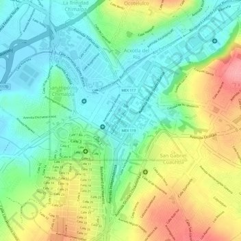
Nom : Carte topographique Tlaxcala de Xicohténcatl, altitude, relief.
Altitude moyenne : 2 268 m
Altitude minimum : 2 223 m
Altitude maximum : 2 337 m
Autres cartes topographiques
Cliquez sur une carte pour visualiser sa topographie, son altitude et son relief.
Tlaxcala City
Mexico > Tlaxcala > Municipio de Tlaxcala
The city is located in the central Mexican highlands 2,239 metres (7,346 feet) above sea level, in a valley of the same name, from which the Popocatépetl and Iztaccíhuatl volcanoes can be seen in the distance. The main elevations in the municipality are El Cerro Ostol at 2,460 metres (8,070 feet) and El…
Altitude moyenne : 2 414 m