
Carte topographique South Shore Lake Superior Fish and Wildlife Area
Carte interactive
Cliquez sur la carte pour afficher l’altitude.
À propos de cette carte
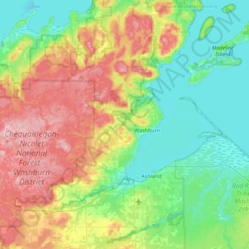
Nom : Carte topographique South Shore Lake Superior Fish and Wildlife Area, altitude, relief.
Altitude moyenne : 261 m
Altitude minimum : 176 m
Altitude maximum : 446 m
Autres cartes topographiques
Cliquez sur une carte pour visualiser sa topographie, son altitude et son relief.
Red Cliff
United States > Wisconsin > Bayfield County
Red Cliff, Town of Russell, Bayfield County, Wisconsin, 54814, United States
Altitude moyenne : 215 m