
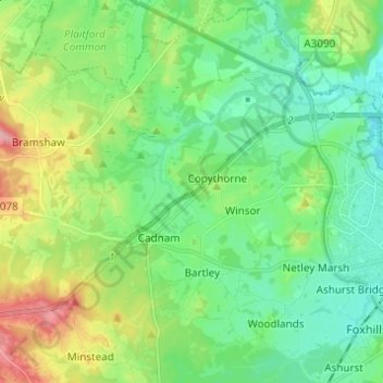
Carte topographique Copythorne
Carte interactive
Cliquez sur la carte pour afficher l’altitude.
À propos de cette carte
Nom : Carte topographique Copythorne, altitude, relief.
Altitude moyenne : 36 m
Altitude minimum : -2 m
Altitude maximum : 120 m
Autres cartes topographiques
Cliquez sur une carte pour visualiser sa topographie, son altitude et son relief.
Martin
United Kingdom > England > New Forest
Martin, New Forest, Hampshire, South East, England, United Kingdom
Altitude moyenne : 103 m
Lymington and Pennington
United Kingdom > England > New Forest
Lymington and Pennington, New Forest, Hampshire, South East, England, United Kingdom
Altitude moyenne : 9 m
Fordingbridge
United Kingdom > England > New Forest
Fordingbridge, New Forest, Hampshire, South East, England, United Kingdom
Altitude moyenne : 46 m
Totton and Eling
United Kingdom > England > New Forest
Totton and Eling, New Forest, Hampshire, South East, England, United Kingdom
Altitude moyenne : 13 m