
Carte topographique Ehrenbreitstein
Carte interactive
Cliquez sur la carte pour afficher l’altitude.
À propos de cette carte
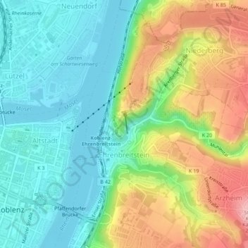
Nom : Carte topographique Ehrenbreitstein, altitude, relief.
Lieu : Ehrenbreitstein, Koblenz, Rijnland-Palts, 56077, Duitsland (50.35593 7.60659 50.36924 7.63660)
Altitude moyenne : 119 m
Altitude minimum : 62 m
Altitude maximum : 220 m
Autres cartes topographiques
Cliquez sur une carte pour visualiser sa topographie, son altitude et son relief.
Koblenz
Duitsland > Rijnland-Palts > Koblenz
Koblenz, Rijnland-Palts, 56068, Duitsland
Altitude moyenne : 240 m