
Carte topographique Ilmenau
Carte interactive
Cliquez sur la carte pour afficher l’altitude.
À propos de cette carte
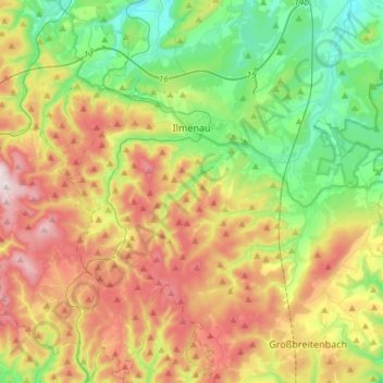
Nom : Carte topographique Ilmenau, altitude, relief.
Lieu : Ilmenau, Ilm-Kreis, Thuringia, Germany (50.56143 10.81823 50.74946 11.06661)
Altitude moyenne : 604 m
Altitude minimum : 364 m
Altitude maximum : 965 m
Ilmenau (German pronunciation: [ˈɪlmənaʊ̯] (listen)) is a town in Thuringia, central Germany. It is the largest town within the Ilm district with a population of 38,600, while the district capital is Arnstadt. Ilmenau is located approximately 33 km (21 miles) south of Erfurt and 135 km (84 miles) north of Nuremberg within the Ilm valley at the northern edge of the Thuringian Forest at an elevation of 500 metres (1,640 feet).
Autres cartes topographiques
Cliquez sur une carte pour visualiser sa topographie, son altitude et son relief.
Großbreitenbach
Germany > Thuringia > Ilm-Kreis > Großbreitenbach
Großbreitenbach, Ilm-Kreis, Thuringia, Germany
Altitude moyenne : 596 m
Burg Ehrenstein
Germany > Thuringia > Ilm-Kreis > Stadtilm > Ehrenstein
Burg Ehrenstein, Ehrenstein, Stadtilm, Ilm-Kreis, Thuringia, 99326, Germany
Altitude moyenne : 415 m