
Carte topographique Chochołów
Carte interactive
Cliquez sur la carte pour afficher l’altitude.
À propos de cette carte
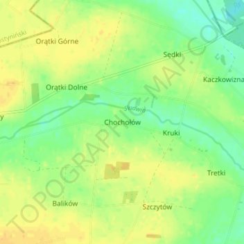
Nom : Carte topographique Chochołów, altitude, relief.
Altitude moyenne : 96 m
Altitude minimum : 82 m
Altitude maximum : 108 m
Autres cartes topographiques
Cliquez sur une carte pour visualiser sa topographie, son altitude et son relief.
Cygany
Poland > Łódzkie Voivodship > Kutno County
Cygany, gmina Krośniewice, Kutno County, Łódzkie Voivodship, Poland
Altitude moyenne : 124 m