
Carte topographique Gampaha
Carte interactive
Cliquez sur la carte pour afficher l’altitude.
À propos de cette carte
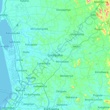
Nom : Carte topographique Gampaha, altitude, relief.
Lieu : Gampaha, Gampaha District, Western Province, 11000, Sri Lanka (6.93256 79.83514 7.25256 80.15514)
Altitude moyenne : 24 m
Altitude minimum : -1 m
Altitude maximum : 229 m
Autres cartes topographiques
Cliquez sur une carte pour visualiser sa topographie, son altitude et son relief.
Welipillewa Junction
Sri Lanka > Western Province > Gampaha
Welipillewa Junction, Gampaha, Gampaha District, Western Province, 11000, Sri Lanka
Altitude moyenne : 28 m
Kalu Katuwe Ela
Sri Lanka > Western Province > Gampaha
Kalu Katuwe Ela, Gampaha Pahalagama, Gampaha, Gampaha District, Western Province, 63.A.63, Sri Lanka
Altitude moyenne : 13 m