
Faire un don
Équipez-vous pour votre prochaine aventure :
En tant que Partenaire Amazon, ce site perçoit une commission sur les achats éligibles sans surcoût pour vous.
Carte topographique Seyboldsdorf
Cliquez sur la carte pour afficher l’altitude.
Faire un don
Équipez-vous pour votre prochaine aventure :
En tant que Partenaire Amazon, ce site perçoit une commission sur les achats éligibles sans surcoût pour vous.
Seyboldsdorf
Das Pfarrdorf Seyboldsdorf liegt gut drei Kilometer nördlich von Vilsbiburg auf einem Höhenrücken im Isar-Inn-Hügelland zwischen Großer und Kleiner Vils.
Faire un don
Équipez-vous pour votre prochaine aventure :
En tant que Partenaire Amazon, ce site perçoit une commission sur les achats éligibles sans surcoût pour vous.
À propos de cette carte
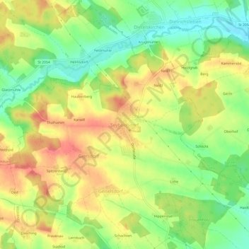
Nom : Carte topographique Seyboldsdorf, altitude, relief.
Altitude moyenne : 470 m
Altitude minimum : 435 m
Altitude maximum : 504 m
Faire un don
Équipez-vous pour votre prochaine aventure :
En tant que Partenaire Amazon, ce site perçoit une commission sur les achats éligibles sans surcoût pour vous.
Autres cartes topographiques
Cliquez sur une carte pour visualiser sa topographie, son altitude et son relief.
84137
Deutschland > Bayern > Landkreis Landshut > Vilsbiburg > Gaindorf > Berg
Altitude moyenne : 455 m