
Carte topographique Muara Enim
Carte interactive
Cliquez sur la carte pour afficher l’altitude.
Muara Enim
The resulting twenty-two districts (including the six now in the new Rambang Lubai Lematang Regency) are listed below with their areas and their populations at the 2010 Census and the 2020 Census, together with the official estimates as at mid 2022. The table also includes the locations of the district administrative centres, together with the number of villages in each district(comprising 245 rural desa and 10 urban kelurahan), and their post code(s). The topography of the regency comprised a southern group of five districts with an altitude of over 100 metres above sea level in the Bukit Barisan mountain chain, a west-central group of five districts, an east-central group of six districts (those split off in late 2022), and a northern group of six districts of mainly swamp area facing directly with the Musi River basin, which (since the creation of the Penukal Abab Lematang Ilir Regency in 2013) are physically separated from the rest of the Muara Enim Regency by the city of Prabumulih.
À propos de cette carte
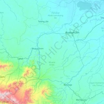
Nom : Carte topographique Muara Enim, altitude, relief.
Lieu : Muara Enim, South Sumatra, Sumatra, Indonesia (-4.37709 103.31605 -3.01184 104.56449)
Altitude moyenne : 280 m
Altitude minimum : 1 m
Altitude maximum : 3 145 m
Autres cartes topographiques
Cliquez sur une carte pour visualiser sa topographie, son altitude et son relief.