
Faire un don
Équipez-vous pour votre prochaine aventure :
En tant que Partenaire Amazon, ce site perçoit une commission sur les achats éligibles sans surcoût pour vous.
Carte topographique Baglung
Cliquez sur la carte pour afficher l’altitude.
Faire un don
Équipez-vous pour votre prochaine aventure :
En tant que Partenaire Amazon, ce site perçoit une commission sur les achats éligibles sans surcoût pour vous.
Baglung
Baglung enjoys warm summers and mild winters. Annual average temperatures range from a maximum of 26.6 °C (79.9 °F) and a minimum of 19.1 °C (66.4 °F). Highs above 35 °C (95 °F) and lows below 0 °C (32 °F) are rare. The average annual rainfall recorded is 1,060.9 mm (41.77 in) in 1982. Rainfall is heavily affected by the monsoon and most of it occurs during the months of June through September. Rest of the year is mostly dry and sunny. Snowfall is extremely rare in the city core, however, higher elevations within the city limits see occasional snow during the winter months. Due to large topographic variation climate ranging from hot subtropical to temperate montane climate can be experienced within the city limits.
Faire un don
Équipez-vous pour votre prochaine aventure :
En tant que Partenaire Amazon, ce site perçoit une commission sur les achats éligibles sans surcoût pour vous.
À propos de cette carte
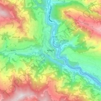
Nom : Carte topographique Baglung, altitude, relief.
Lieu : Baglung, Gandaki Province, Nepal (28.22511 83.56299 28.30511 83.64299)
Altitude moyenne : 1 358 m
Altitude minimum : 712 m
Altitude maximum : 2 288 m
Faire un don
Équipez-vous pour votre prochaine aventure :
En tant que Partenaire Amazon, ce site perçoit une commission sur les achats éligibles sans surcoût pour vous.
Autres cartes topographiques
Cliquez sur une carte pour visualiser sa topographie, son altitude et son relief.