
Carte topographique Gaborone
Carte interactive
Cliquez sur la carte pour afficher l’altitude.
À propos de cette carte
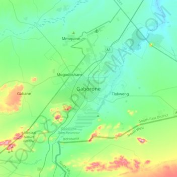
Nom : Carte topographique Gaborone, altitude, relief.
Lieu : Gaborone, South-East District, Botswana (-24.81814 25.74885 -24.49814 26.06885)
Altitude moyenne : 1 032 m
Altitude minimum : 946 m
Altitude maximum : 1 364 m
Gaborone is situated at 24°39′29″S 25°54′44″E / 24.65806°S 25.91222°E / -24.65806; 25.91222 between Kgale and Oodi Hills, on the Notwane River in the south-eastern corner of Botswana, and 15 kilometres (9.3 mi) from the South African border The city lies at an elevation of 1,010 metres (3,310 ft) above sea level. Gaborone is surrounded by the following cities: Ramotswa to the southeast, Mogoditshane to the northwest, and Mochudi to the east, and Tlokweng across the river. Most of them are commuter towns for Gaborone. Suburbs in Gaborone include Broadhurst, Gaborone West, The Village, Naledi. Phakalane, an affluent suburb, lies about 13 km north of the city center.
Autres cartes topographiques
Cliquez sur une carte pour visualiser sa topographie, son altitude et son relief.
Gaborone Dam
Botswana > South-East District > Gaborone
Gaborone Dam, Gaborone, South-East District, Botswana
Altitude moyenne : 992 m