
Carte topographique Bull Shoals Lake
Carte interactive
Cliquez sur la carte pour afficher l’altitude.
À propos de cette carte
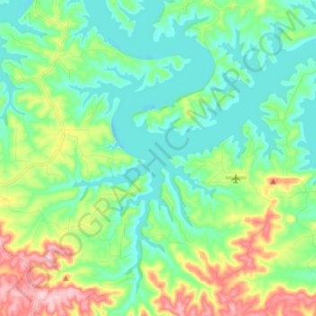
Nom : Carte topographique Bull Shoals Lake, altitude, relief.
Altitude moyenne : 246 m
Altitude minimum : 189 m
Altitude maximum : 390 m
Bull Shoals Lake impounds the White River for the last time as water travels toward its mouth on the Mississippi River. Bull Shoals is thus the lake farthest downstream in a chain of four artificial lakes that include (from upstream to downstream) Beaver Lake, Table Rock Lake and Lake Taneycomo. The lake is controlled by the Army Corps of Engineers and has the primary purpose of flood control. The level of the lake fluctuates regularly with a normal pool level elevation of 654 feet above sea level, which is locally known as powerpool. However, the lake regularly fluctuates between an elevation of 630 to 680 feet. The upper part of the lake, below nearby Powersite Dam, is known as the "Pothole".