
Carte topographique Quảng Ninh District
Carte interactive
Cliquez sur la carte pour afficher l’altitude.
À propos de cette carte
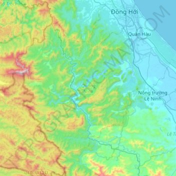
Nom : Carte topographique Quảng Ninh District, altitude, relief.
Lieu : Quảng Ninh District, Quang Binh province, Vietnam (17.07085 106.28730 17.43613 106.79671)
Altitude moyenne : 308 m
Altitude minimum : -3 m
Altitude maximum : 1 597 m
Autres cartes topographiques
Cliquez sur une carte pour visualiser sa topographie, son altitude et son relief.
Phong Nha Town
Vietnam > Quang Binh province > Bố Trạch District
Phong Nha Town, Bố Trạch District, Quảng Bình Province, Vietnam
Altitude moyenne : 66 m
Bố Trạch District
Bố Trạch District, Quang Binh province, Vietnam
Altitude moyenne : 356 m
Kiến Giang
Vietnam > Quang Binh province > Kiến Giang
Kiến Giang, Lệ Thủy District, Quang Binh province, Vietnam
Altitude moyenne : 3 m