
Carte topographique Oakridge
Carte interactive
Cliquez sur la carte pour afficher l’altitude.
À propos de cette carte
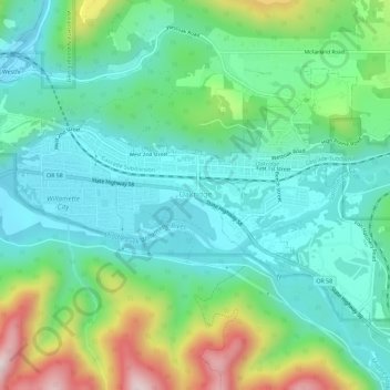
Nom : Carte topographique Oakridge, altitude, relief.
Lieu : Oakridge, Lane County, Oregon, United States (43.73131 -122.49623 43.75831 -122.43861)
Altitude moyenne : 465 m
Altitude minimum : 323 m
Altitude maximum : 848 m
The city was originally a community called "Hazeldell", and its post office was established on July 26, 1888. When a station on the Southern Pacific Railroad opened in May 1912, it was named "Oak Ridge" by a railroad executive for the surrounding topography, and on July 19 of that year the name was changed to be spelled as a single word.
Autres cartes topographiques
Cliquez sur une carte pour visualiser sa topographie, son altitude et son relief.
Cottage Grove
United States > Oregon > Lane County
Cottage Grove, Lane County, Oregon, 97424, United States
Altitude moyenne : 230 m
Springfield
United States > Oregon > Lane County
Springfield, Lane County, Oregon, United States
Altitude moyenne : 177 m
Eugene
United States > Oregon > Lane County
Eugene, Lane County, Oregon, United States
Altitude moyenne : 163 m