
Carte topographique Redmond
Carte interactive
Cliquez sur la carte pour afficher l’altitude.
À propos de cette carte
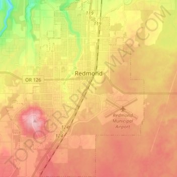
Nom : Carte topographique Redmond, altitude, relief.
Lieu : Redmond, Deschutes County, Oregon, 97756, United States (44.22580 -121.23475 44.31077 -121.13355)
Altitude moyenne : 921 m
Altitude minimum : 830 m
Altitude maximum : 987 m
The city encompasses 15.5 square miles (40 km2) and is on a plateau, at an elevation of 3,077 feet (938 m). Redmond is 15 miles (24 km) north of Bend—the county seat of Deschutes County—144 miles (232 km) from Portland, 129 miles (208 km) from Salem—the capital of Oregon—and 126 miles (203 km) from Eugene.