
Carte topographique Usingen
Carte interactive
Cliquez sur la carte pour afficher l’altitude.
À propos de cette carte
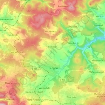
Nom : Carte topographique Usingen, altitude, relief.
Lieu : Usingen, Hochtaunuskreis, Hesse, 61250, Germany (50.30307 8.43338 50.39819 8.61202)
Altitude moyenne : 356 m
Altitude minimum : 198 m
Altitude maximum : 557 m
The town core is about 300 m above sea level. The highest elevation in the main town of Usingen is the Hohe Berg ("High Mountain"), 414 m above sea level.