
Carte topographique Breda
Carte interactive
Cliquez sur la carte pour afficher l’altitude.
À propos de cette carte
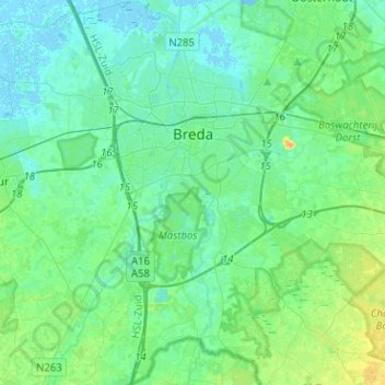
Nom : Carte topographique Breda, altitude, relief.
Lieu : Breda, North Brabant, Netherlands (51.48555 4.68601 51.64320 4.84573)
Altitude moyenne : 7 m
Altitude minimum : -2 m
Altitude maximum : 27 m
Topographic map image of the city of Breda, March 2014. Click to enlarge.
Autres cartes topographiques
Cliquez sur une carte pour visualiser sa topographie, son altitude et son relief.
's-Hertogenbosch
's-Hertogenbosch, North Brabant, Netherlands
Altitude moyenne : 4 m
Veldhoven
Netherlands > North Brabant > Veldhoven
Veldhoven, North Brabant, Netherlands
Altitude moyenne : 23 m
Mill
Netherlands > North Brabant > Mill en Sint Hubert
Mill, Mill en Sint Hubert, North Brabant, Netherlands
Altitude moyenne : 14 m
Eindhoven
Netherlands > North Brabant > Eindhoven
Eindhoven, North Brabant, Netherlands
Altitude moyenne : 20 m