
Carte topographique Baltimore Township
Carte interactive
Cliquez sur la carte pour afficher l’altitude.
À propos de cette carte
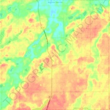
Nom : Carte topographique Baltimore Township, altitude, relief.
Lieu : Baltimore Township, Barry County, Michigan, United States (42.50787 -85.30810 42.59623 -85.19063)
Altitude moyenne : 280 m
Altitude minimum : 244 m
Altitude maximum : 308 m
Autres cartes topographiques
Cliquez sur une carte pour visualiser sa topographie, son altitude et son relief.
Deep Lake
United States > Michigan > Barry County
Deep Lake, Yankee Springs Township, Barry County, Michigan, United States
Altitude moyenne : 269 m
Orr Lake
United States > Michigan > Barry County
Orr Lake, Orangeville Township, Barry County, Michigan, United States
Altitude moyenne : 286 m
Gun Lake
United States > Michigan > Barry County
Gun Lake, Yankee Springs Township, Barry County, Michigan, United States
Altitude moyenne : 234 m
Carlton Township
United States > Michigan > Barry County
Carlton Township, Barry County, Michigan, United States
Altitude moyenne : 255 m