
Carte topographique Niedermurach
Carte interactive
Cliquez sur la carte pour afficher l’altitude.
À propos de cette carte
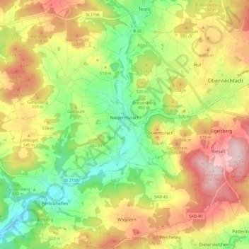
Nom : Carte topographique Niedermurach, altitude, relief.
Altitude moyenne : 513 m
Altitude minimum : 383 m
Altitude maximum : 660 m
Autres cartes topographiques
Cliquez sur une carte pour visualiser sa topographie, son altitude et son relief.
Siegelsdorf
Germany > Bavaria > Landkreis Schwandorf
Siegelsdorf, Altendorf, Nabburg (VGem), Landkreis Schwandorf, Bavaria, 92540, Germany
Altitude moyenne : 434 m