
Carte topographique Volcán Calbuco
Carte interactive
Cliquez sur la carte pour afficher l’altitude.
À propos de cette carte
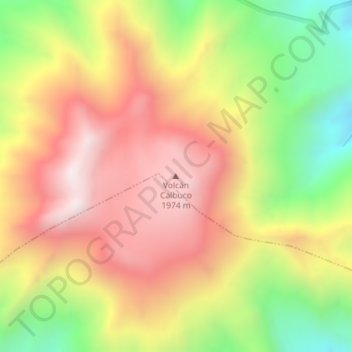
Nom : Carte topographique Volcán Calbuco, altitude, relief.
Altitude moyenne : 1 581 m
Altitude minimum : 1 111 m
Altitude maximum : 1 990 m
Calbuco (/kɑːlˈbuːkoʊ/ kahl-BOO-koh; Spanish: Volcán Calbuco, pronounced ) is a stratovolcano in southern Chile, located southeast of Llanquihue Lake and northwest of Chapo Lake, in the Los Lagos Region, and close to the cities of Puerto Varas and Puerto Montt. With an elevation of 2,015 meters above sea level, the volcano and the surrounding area are protected within the Llanquihue National Reserve.
Autres cartes topographiques
Cliquez sur une carte pour visualiser sa topographie, son altitude et son relief.
Osorno Volcano
Chile > Los Lagos Region > Provincia de Llanquihue > Puerto Varas
Osorno Volcano, Puerto Varas, Provincia de Llanquihue, Los Lagos Region, Chile
Altitude moyenne : 1 994 m
Nueva Braunau
Chile > Los Lagos Region > Provincia de Llanquihue > Puerto Varas
Nueva Braunau, Puerto Varas, Provincia de Llanquihue, Los Lagos Region, Chile
Altitude moyenne : 105 m