
Carte topographique Borujerd City
Carte interactive
Cliquez sur la carte pour afficher l’altitude.
Borujerd City
Borujerd city is located approximately 1670 meters above sea level and has a moderate climate with cold winters. The highest point is Garrin Mountain 3623 m above sea level and the lowest area is Gelerood River in South with 1400 m elevation. Borujerd Township has 2600 km2 area with approximately 400,000 inhabitants distributed in the city of Oshtorinan and more than 180 villages. Owing to favorable topographic and climatic conditions, the plains are devoted to cultivation of grain. Wherever irrigation is possible (by means of qanāts, wells, diversion of water of streams), cotton, melons, grapes, and fruit trees (especially almonds) are grown.
À propos de cette carte
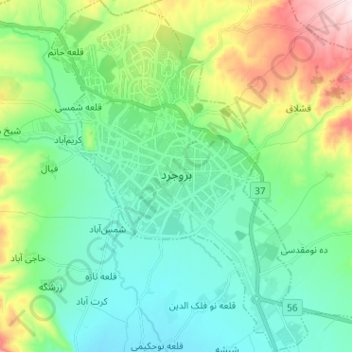
Nom : Carte topographique Borujerd City, altitude, relief.
Altitude moyenne : 1 621 m
Altitude minimum : 1 500 m
Altitude maximum : 1 963 m
Autres cartes topographiques
Cliquez sur une carte pour visualiser sa topographie, son altitude et son relief.