
Carte topographique Ontonagon County
Carte interactive
Cliquez sur la carte pour afficher l’altitude.
À propos de cette carte
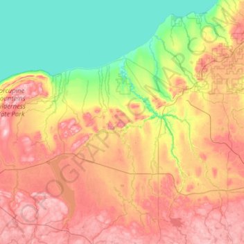
Nom : Carte topographique Ontonagon County, altitude, relief.
Lieu : Ontonagon County, Michigan, USA (46.33038 -89.88539 47.02891 -88.86374)
Altitude moyenne : 335 m
Altitude minimum : 175 m
Altitude maximum : 587 m
Autres cartes topographiques
Cliquez sur une carte pour visualiser sa topographie, son altitude et son relief.
Sterling Heights
USA > Michigan > Sterling Heights
Sterling Heights, Macomb County, Michigan, USA
Altitude moyenne : 191 m
Pleasant Ridge
USA > Michigan > Pleasant Ridge
Pleasant Ridge, Oakland County, Michigan, USA
Altitude moyenne : 201 m
East Lansing
USA > Michigan > East Lansing
East Lansing, Ingham County, Michigan, USA
Altitude moyenne : 261 m
Isle Royale National Park
Isle Royale National Park, Greenstone Ridge Trail, Houghton Township, Keweenaw County, Michigan, USA
Altitude moyenne : 189 m