
Carte topographique Lochgelly
Carte interactive
Cliquez sur la carte pour afficher l’altitude.
À propos de cette carte
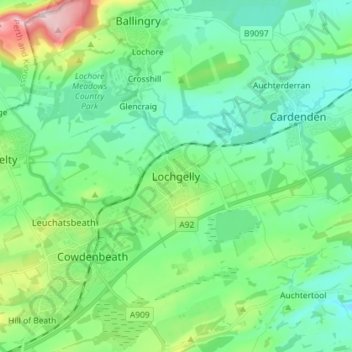
Nom : Carte topographique Lochgelly, altitude, relief.
Lieu : Lochgelly, Fife, Scotland, KY5 9QN, United Kingdom (56.08932 -3.34984 56.16932 -3.26984)
Altitude moyenne : 122 m
Altitude minimum : 50 m
Altitude maximum : 352 m
Autres cartes topographiques
Cliquez sur une carte pour visualiser sa topographie, son altitude et son relief.
Glenrothes
United Kingdom > Scotland > Fife
Glenrothes, Fife, Scotland, KY7 5LW, United Kingdom
Altitude moyenne : 106 m
St Andrews
United Kingdom > Scotland > Fife
St Andrews, Fife, Scotland, KY16 9PA, United Kingdom
Altitude moyenne : 38 m
Fordell
United Kingdom > Scotland > Fife > Fordell
Fordell, Crossgates and Mossgreen, Fife, Scotland, KY4 8EY, United Kingdom
Altitude moyenne : 129 m