
Carte topographique Lübeck
Carte interactive
Cliquez sur la carte pour afficher l’altitude.
À propos de cette carte
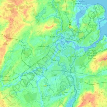
Nom : Carte topographique Lübeck, altitude, relief.
Lieu : Lübeck, Schleswig-Holstein, Germany (53.76801 10.55404 53.99389 10.96863)
Altitude moyenne : 25 m
Altitude minimum : -4 m
Altitude maximum : 109 m
Autres cartes topographiques
Cliquez sur une carte pour visualiser sa topographie, son altitude et son relief.
Kiel
Germany > Schleswig-Holstein > Kiel
Kiel, Schleswig-Holstein, 24103, Germany
Altitude moyenne : 24 m
Lübeck
Germany > Schleswig-Holstein > Lübeck
Lübeck, Schleswig-Holstein, 23552, Germany
Altitude moyenne : 29 m
Schaalsee
Germany > Schleswig-Holstein > Seedorf
Schaalsee, Bokop, Seedorf, Lauenburgische Seen, Herzogtum Lauenburg, Schleswig-Holstein, 23883, Germany
Altitude moyenne : 43 m