
Carte topographique Taylorsville
Carte interactive
Cliquez sur la carte pour afficher l’altitude.
À propos de cette carte
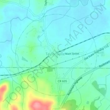
Nom : Carte topographique Taylorsville, altitude, relief.
Lieu : Taylorsville, Bartow County, Georgia, United States (34.07600 -84.99958 34.09604 -84.97556)
Altitude moyenne : 227 m
Altitude minimum : 207 m
Altitude maximum : 306 m
Autres cartes topographiques
Cliquez sur une carte pour visualiser sa topographie, son altitude et son relief.
Cartersville
United States > Georgia > Bartow County
Cartersville, Bartow County, Georgia, 30120, United States
Altitude moyenne : 260 m
Rydal
United States > Georgia > Bartow County
Rydal, Bartow County, Georgia, 30171, United States
Altitude moyenne : 273 m
White
United States > Georgia > Bartow County
White, Bartow County, Georgia, United States
Altitude moyenne : 271 m
Emerson
United States > Georgia > Bartow County
Emerson, Bartow County, Georgia, 30137, United States
Altitude moyenne : 254 m
Euharlee
United States > Georgia > Bartow County
Euharlee, Bartow County, Georgia, United States
Altitude moyenne : 215 m
Red Top Mountain State Park
United States > Georgia > Bartow County
Red Top Mountain State Park, Bartow County, Georgia, United States
Altitude moyenne : 276 m
Adairsville
United States > Georgia > Bartow County
Adairsville, Bartow County, Georgia, 30103, United States
Altitude moyenne : 254 m
Weiss Lake
United States > Georgia > Bartow County > Cartersville
Weiss Lake, Cartersville, Bartow County, Georgia, United States
Altitude moyenne : 276 m
Emerson
United States > Georgia > Bartow County > Emerson
Emerson, Bartow County, Georgia, 30137, United States
Altitude moyenne : 266 m
Kingston
United States > Georgia > Bartow County
Kingston, Bartow County, Georgia, United States
Altitude moyenne : 223 m