
Carte topographique Queen Valley
Carte interactive
Cliquez sur la carte pour afficher l’altitude.
À propos de cette carte
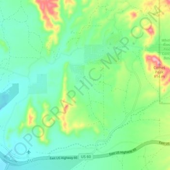
Nom : Carte topographique Queen Valley, altitude, relief.
Lieu : Queen Valley, Pinal County, Arizona, United States (33.25274 -111.34105 33.31838 -111.26798)
Altitude moyenne : 633 m
Altitude minimum : 568 m
Altitude maximum : 804 m
Queen Valley is located at 33°17′42″N 111°17′52″W / 33.29500°N 111.29778°W / 33.29500; -111.29778. at an elevation of 2000 feet along the south side of the west flowing Queen Creek. The Tonto National Forest boundary and Comet Peak (2681 ft.) lie 1.5 miles to the east. The dam for the Whitlow Ranch Flood Control Basin is one mile to the east.
Autres cartes topographiques
Cliquez sur une carte pour visualiser sa topographie, son altitude et son relief.
San Tan Valley
United States > Arizona > Pinal County
San Tan Valley, Pinal County, Arizona, 85243, United States
Altitude moyenne : 463 m
Casa Grande
United States > Arizona > Pinal County
Casa Grande, Pinal County, Arizona, United States
Altitude moyenne : 439 m
Tiger
United States > Arizona > Pinal County
Tiger, Pinal County, Arizona, 85618, United States
Altitude moyenne : 928 m