
Carte topographique Yates Natural Area
Carte interactive
Cliquez sur la carte pour afficher l’altitude.
À propos de cette carte
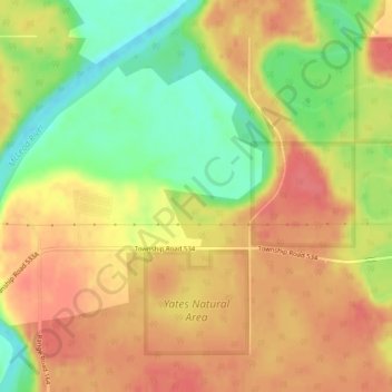
Nom : Carte topographique Yates Natural Area, altitude, relief.
Altitude moyenne : 880 m
Altitude minimum : 842 m
Altitude maximum : 905 m
Autres cartes topographiques
Cliquez sur une carte pour visualiser sa topographie, son altitude et son relief.
Brazeau River Provincial Recreation Area
Canada > Alberta > Yellowhead County
Brazeau River Provincial Recreation Area, Forestry Trunk Road, Yellowhead County, Alberta, Canada
Altitude moyenne : 1 325 m
Brule
Canada > Alberta > Yellowhead County
Brule, Yellowhead County, Alberta, Canada
Altitude moyenne : 1 135 m
Rock Lake Provincial Park
Canada > Alberta > Yellowhead County
Rock Lake Provincial Park, Yellowhead County, Alberta, Canada
Altitude moyenne : 1 612 m
Peers
Canada > Alberta > Yellowhead County
Peers, Yellowhead County, Alberta, Canada
Altitude moyenne : 850 m
Fairfax Lake
Canada > Alberta > Yellowhead County
Fairfax Lake, Yellowhead County, Alberta, Canada
Altitude moyenne : 1 347 m
Folding Mountain
Canada > Alberta > Yellowhead County
Folding Mountain, Yellowhead County, Alberta, Canada
Altitude moyenne : 1 806 m
Robb
Canada > Alberta > Yellowhead County
Robb, Yellowhead County, Alberta, Canada
Altitude moyenne : 1 142 m
Luscar
Canada > Alberta > Yellowhead County
Luscar, Yellowhead County, Alberta, Canada
Altitude moyenne : 1 718 m