
Faire un don
Équipez-vous pour votre prochaine aventure :
En tant que Partenaire Amazon, ce site perçoit une commission sur les achats éligibles sans surcoût pour vous.
Carte topographique Aragona
Cliquez sur la carte pour afficher l’altitude.
Faire un don
Équipez-vous pour votre prochaine aventure :
En tant que Partenaire Amazon, ce site perçoit une commission sur les achats éligibles sans surcoût pour vous.
Aragona
Aragona is located on the eastern slopes of the Mount Belvedere at an altitude of 428 m. In the 13th century, the Castello di Barrugeri was built near what is now Aragona, but it no longer exists. The town was founded on 6 January 1606, upon the initiative of lord Baldassare III Naselli, Count of Comiso. He had previously submitted a request for the foundation of a new village in his fiefdom of Diesi during the 49th Extraordinary General Parliament, overseen by the Spanish viceroy Lorenzo Suarez de Figueroa e Cordoba on 2 August 1604, in Messina. On 6 September that year the viceroy ordered an official investigation into the matter, which eventually resulted on 6 January 1606 in the granting of a licentia populandi, i.e. the permission to increase the fief's population. The new village was named after the Count's mother, donna Beatrice Aragona Branciforti.
Faire un don
Équipez-vous pour votre prochaine aventure :
En tant que Partenaire Amazon, ce site perçoit une commission sur les achats éligibles sans surcoût pour vous.
À propos de cette carte
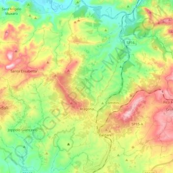
Nom : Carte topographique Aragona, altitude, relief.
Lieu : Aragona, Agrigento, Sicily, 92021, Italy (37.35326 13.55943 37.48766 13.66292)
Altitude moyenne : 302 m
Altitude minimum : 87 m
Altitude maximum : 624 m
Faire un don
Équipez-vous pour votre prochaine aventure :
En tant que Partenaire Amazon, ce site perçoit une commission sur les achats éligibles sans surcoût pour vous.
Autres cartes topographiques
Cliquez sur une carte pour visualiser sa topographie, son altitude et son relief.
Faire un don
Équipez-vous pour votre prochaine aventure :
En tant que Partenaire Amazon, ce site perçoit une commission sur les achats éligibles sans surcoût pour vous.