
Carte topographique Oildale
Carte interactive
Cliquez sur la carte pour afficher l’altitude.
À propos de cette carte
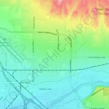
Nom : Carte topographique Oildale, altitude, relief.
Lieu : Oildale, Kern County, California, United States (35.39717 -119.06108 35.45965 -119.00119)
Altitude moyenne : 164 m
Altitude minimum : 123 m
Altitude maximum : 271 m
Oildale is a census-designated place (CDP) in Kern County, California, United States. Oildale is located 3.5 miles (5.6 km) north-northwest of downtown Bakersfield, at an elevation of 469 feet (143 m). The population was 32,684 at the 2010 census, up from 27,885 at the 2000 census. It is an unincorporated suburban town just north of Bakersfield across the Kern River, west of the Kern River Oil Field, and east of Highway 99.
Autres cartes topographiques
Cliquez sur une carte pour visualiser sa topographie, son altitude et son relief.
Bakersfield
United States > California > Kern County
Bakersfield, Kern County, California, United States
Altitude moyenne : 157 m
Bear Valley Springs
United States > California > Kern County
Bear Valley Springs, Kern County, California, United States
Altitude moyenne : 1 204 m
Frazier Park
United States > California > Kern County
Frazier Park, Kern County, California, United States
Altitude moyenne : 1 533 m
Ridgecrest
United States > California > Kern County
Ridgecrest, Kern County, California, 93555, United States
Altitude moyenne : 739 m
Fellows
United States > California > Kern County
Fellows, Kern County, California, United States
Altitude moyenne : 420 m
Potomac County Park
United States > California > Kern County
Potomac County Park, Kern County, California, United States
Altitude moyenne : 130 m
East Bakersfield
United States > California > Kern County
East Bakersfield, Kern County, California, 93305, United States
Altitude moyenne : 158 m
Hillcrest Point
United States > California > Kern County
Hillcrest Point, Kern County, California, United States
Altitude moyenne : 411 m
Rosedale
United States > California > Kern County
Rosedale, Kern County, California, United States
Altitude moyenne : 113 m
Shafter
United States > California > Kern County
Shafter, Kern County, California, 93253, United States
Altitude moyenne : 108 m
South Taft
United States > California > Kern County > Taft > South Taft
South Taft, Taft, Kern County, California, United States
Altitude moyenne : 343 m
Kernville
United States > California > Kern County
Kernville, Kern County, California, 93238, United States
Altitude moyenne : 1 135 m
Ford City
United States > California > Kern County > Taft
Ford City, Taft, Kern County, California, United States
Altitude moyenne : 264 m
Buttonwillow
United States > California > Kern County
Buttonwillow, Kern County, California, 93206, United States
Altitude moyenne : 87 m
Shirley Meadows
United States > California > Kern County
Shirley Meadows, Kern County, California, United States
Altitude moyenne : 1 848 m
Blue Moon Ranch
United States > California > Kern County
Blue Moon Ranch, Kern County, California, United States
Altitude moyenne : 77 m
Bakersfield
United States > California > Kern County > Bakersfield
Bakersfield, Kern County, California, 93301, United States
Altitude moyenne : 161 m
Lost Hills
United States > California > Kern County
Lost Hills, Kern County, California, 93249, United States
Altitude moyenne : 82 m
Lokern
United States > California > Kern County
Lokern, Kern County, California, United States
Altitude moyenne : 89 m
Brown
United States > California > Kern County
Brown, Kern County, California, United States
Altitude moyenne : 732 m
Bodfish
United States > California > Kern County
Bodfish, Kern County, California, 93205, United States
Altitude moyenne : 897 m
Lebec
United States > California > Kern County
Lebec, Kern County, California, 93243, United States
Altitude moyenne : 1 162 m
Quailwood
United States > California > Kern County > Bakersfield
Quailwood, Bakersfield, Kern County, CAL Fire Southern Region, California, 93309, United States
Altitude moyenne : 119 m
Rancho Seco
United States > California > Kern County
Rancho Seco, Kern County, California, United States
Altitude moyenne : 623 m
Stallion Springs
United States > California > Kern County > Stallion Springs
Stallion Springs, Kern County, California, United States
Altitude moyenne : 1 197 m
Brite Lake Recreational Park
United States > California > Kern County
Brite Lake Recreational Park, Kern County, California, United States
Altitude moyenne : 1 354 m
Shafter
United States > California > Kern County
Shafter, City of Shafter, Kern County, CAL Fire Southern Region, California, United States
Altitude moyenne : 120 m
California City
United States > California > Kern County
California City, Kern County, California, United States
Altitude moyenne : 845 m
Wofford Heights
United States > California > Kern County
Wofford Heights, Kern County, California, 93285, United States
Altitude moyenne : 1 114 m
Rosedale
United States > California > Kern County
Rosedale, Kern County, CAL Fire Contract Counties, California, United States
Altitude moyenne : 107 m
Greenfield
United States > California > Kern County
Greenfield, Kern County, California, United States
Altitude moyenne : 106 m
Twin Oaks
United States > California > Kern County
Twin Oaks, Kern County, California, United States
Altitude moyenne : 945 m
Delano
United States > California > Kern County
Delano, Kern County, California, 93215, United States
Altitude moyenne : 99 m
Keene
United States > California > Kern County
Keene, Kern County, California, United States
Altitude moyenne : 892 m
Golden Hills
United States > California > Kern County
Golden Hills, Kern County, California, 93561, United States
Altitude moyenne : 1 275 m
Grapevine
United States > California > Kern County
Grapevine, Kern County, California, United States
Altitude moyenne : 501 m
Taft Heights
United States > California > Kern County > Taft > Taft Heights
Taft Heights, Taft, Kern County, California, United States
Altitude moyenne : 368 m
Sand Canyon
United States > California > Kern County
Sand Canyon, Kern County, California, United States
Altitude moyenne : 936 m
Smith Corner
United States > California > Kern County
Smith Corner, Kern County, CAL Fire Southern Region, California, 93263, United States
Altitude moyenne : 103 m
Inyokern
United States > California > Kern County
Inyokern, Kern County, California, United States
Altitude moyenne : 753 m
Taft
United States > California > Kern County
Taft, Kern County, California, 93268, United States
Altitude moyenne : 370 m
City of Bakersfield
United States > California > Kern County
City of Bakersfield, Kern County, California, 93304, United States
Altitude moyenne : 120 m
Pine Mountain Club
United States > California > Kern County
Pine Mountain Club, Kern County, CAL Fire Southern Region, California, 93222, United States
Altitude moyenne : 1 867 m
Old River
United States > California > Kern County
Old River, Kern County, California, United States
Altitude moyenne : 103 m
Rosamond
United States > California > Kern County
Rosamond, Kern County, California, 93560, United States
Altitude moyenne : 749 m
Woodford
United States > California > Kern County
Woodford, El Rita, Kern County, California, United States
Altitude moyenne : 899 m
Baker
United States > California > Kern County > Boron
Baker, Boron, Kern County, California, United States
Altitude moyenne : 765 m
Arvin
United States > California > Kern County
Arvin, Kern County, California, United States
Altitude moyenne : 130 m
Indian Rocks
United States > California > Kern County
Indian Rocks, Kern County, California, United States
Altitude moyenne : 346 m
Bradys
United States > California > Kern County > Bradys
Bradys, Kern County, California, 93542, United States
Altitude moyenne : 809 m