
Carte topographique Włóki
Carte interactive
Cliquez sur la carte pour afficher l’altitude.
À propos de cette carte
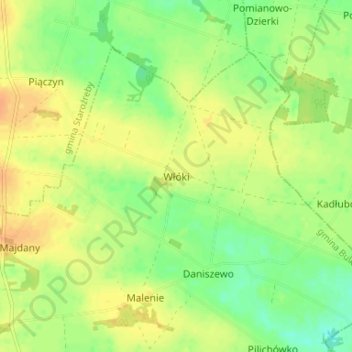
Nom : Carte topographique Włóki, altitude, relief.
Altitude moyenne : 129 m
Altitude minimum : 112 m
Altitude maximum : 142 m
Autres cartes topographiques
Cliquez sur une carte pour visualiser sa topographie, son altitude et son relief.
Sękowo
Poland > Masovian Voivodeship > Płock County
Sękowo, gmina Bielsk, Płock County, Masovian Voivodeship, 09-412, Poland
Altitude moyenne : 128 m
Trzebuń
Poland > Masovian Voivodeship > Płock County > Trzebuń
Trzebuń, gmina Stara Biała, Płock County, Masovian Voivodeship, Poland
Altitude moyenne : 119 m
Małachowo
Poland > Masovian Voivodeship > Płock County > Małachowo
Małachowo, gmina Drobin, Płock County, Masovian Voivodeship, 09-210, Poland
Altitude moyenne : 136 m
Płock
Poland > Masovian Voivodeship > Płock County
Płock, Płock County, Masovian Voivodeship, Poland
Altitude moyenne : 87 m