
Faire un don
Équipez-vous pour votre prochaine aventure :
En tant que Partenaire Amazon, ce site perçoit une commission sur les achats éligibles sans surcoût pour vous.
Carte topographique Rocca Calascio
Cliquez sur la carte pour afficher l’altitude.
Faire un don
Équipez-vous pour votre prochaine aventure :
En tant que Partenaire Amazon, ce site perçoit une commission sur les achats éligibles sans surcoût pour vous.
Rocca Calascio
At an elevation of 1,512 metres (4,961 ft), the castle is the highest fortress in the Apennines. Built of stone and masonry exclusively for military purposes and intended only to accommodate troops and never as residence for nobles, the fortress overlooks the Plain of Navelli at one of the highest points in the ancient Barony of Carapelle.
Faire un don
Équipez-vous pour votre prochaine aventure :
En tant que Partenaire Amazon, ce site perçoit une commission sur les achats éligibles sans surcoût pour vous.
À propos de cette carte
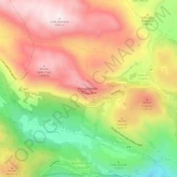
Nom : Carte topographique Rocca Calascio, altitude, relief.
Lieu : Rocca Calascio, Calascio, L'Aquila, Italy (42.30803 13.67077 42.34803 13.71077)
Altitude moyenne : 1 171 m
Altitude minimum : 777 m
Altitude maximum : 1 506 m
Faire un don
Équipez-vous pour votre prochaine aventure :
En tant que Partenaire Amazon, ce site perçoit une commission sur les achats éligibles sans surcoût pour vous.