
Faire un don
Équipez-vous pour votre prochaine aventure :
En tant que Partenaire Amazon, ce site perçoit une commission sur les achats éligibles sans surcoût pour vous.
Carte topographique Dhupgarh
Cliquez sur la carte pour afficher l’altitude.
Faire un don
Équipez-vous pour votre prochaine aventure :
En tant que Partenaire Amazon, ce site perçoit une commission sur les achats éligibles sans surcoût pour vous.
Dhupgarh
Mount Dhupgarh or Dhoopgarh is the highest point in the Mahadeo Hills (Satpura Range), Madhya Pradesh, India. Located in Pachmarhi in Hoshangabad district, it has an elevation of 1,352 metres (4,429 ft). The top of the hill is a popular area to watch sunsets. Pachmarhi Hill station is located close to the peak.[
Faire un don
Équipez-vous pour votre prochaine aventure :
En tant que Partenaire Amazon, ce site perçoit une commission sur les achats éligibles sans surcoût pour vous.
À propos de cette carte
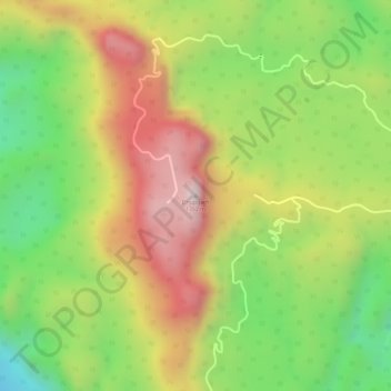
Nom : Carte topographique Dhupgarh, altitude, relief.
Lieu : Dhupgarh, Pipariya Tahsil, Narmadapuram, Madhya Pradesh, India (22.44986 78.37372 22.44996 78.37382)
Altitude moyenne : 1 079 m
Altitude minimum : 814 m
Altitude maximum : 1 334 m
Faire un don
Équipez-vous pour votre prochaine aventure :
En tant que Partenaire Amazon, ce site perçoit une commission sur les achats éligibles sans surcoût pour vous.