
Faire un don
Équipez-vous pour votre prochaine aventure :
En tant que Partenaire Amazon, ce site perçoit une commission sur les achats éligibles sans surcoût pour vous.
Carte topographique Daqing
Cliquez sur la carte pour afficher l’altitude.
Faire un don
Équipez-vous pour votre prochaine aventure :
En tant que Partenaire Amazon, ce site perçoit une commission sur les achats éligibles sans surcoût pour vous.
À propos de cette carte
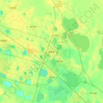
Nom : Carte topographique Daqing, altitude, relief.
Lieu : Daqing, Sartu District, Daqing City, Heilongjiang, China (46.43690 124.94148 46.75690 125.26148)
Altitude moyenne : 148 m
Altitude minimum : 138 m
Altitude maximum : 159 m
Faire un don
Équipez-vous pour votre prochaine aventure :
En tant que Partenaire Amazon, ce site perçoit une commission sur les achats éligibles sans surcoût pour vous.
Autres cartes topographiques
Cliquez sur une carte pour visualiser sa topographie, son altitude et son relief.
Harbin
Harbin, with a total land area of 53,068 km2 (20,490 sq mi), is located in southern Heilongjiang province and is the provincial capital. The prefecture is also located at the southeastern edge of the Songnen Plain, a major part of China's Northeastern Plain. The city center also sits on the southern bank of…
Altitude moyenne : 244 m
Harbin
Harbin, with a total land area of 53,068 km2 (20,490 sq mi), is located in southern Heilongjiang province and is the provincial capital. The prefecture is also located at the southeastern edge of the Songnen Plain, a major part of China's Northeastern Plain. The city center also sits on the southern bank of…
Altitude moyenne : 250 m
Faire un don
Équipez-vous pour votre prochaine aventure :
En tant que Partenaire Amazon, ce site perçoit une commission sur les achats éligibles sans surcoût pour vous.
Amur
China > Heilongjiang > Fuyuan City > Fuyuan
The river rises in the hills in the western part of Northeast China at the confluence of its two major affluents, the Shilka and the Argun (or Ergune), at an elevation of 303 metres (994 ft). It flows east forming the border between China and Russia, and slowly makes a great arc to the southeast for about 400…
Altitude moyenne : 46 m
Harbin
Harbin, with a total land area of 53,068 km2 (20,490 sq mi), is located in southern Heilongjiang province and is the provincial capital. The prefecture is also located at the southeastern edge of the Songnen Plain, a major part of China's Northeastern Plain. The city center also sits on the southern bank of…
Altitude moyenne : 250 m
Faire un don
Équipez-vous pour votre prochaine aventure :
En tant que Partenaire Amazon, ce site perçoit une commission sur les achats éligibles sans surcoût pour vous.
Faire un don
Équipez-vous pour votre prochaine aventure :
En tant que Partenaire Amazon, ce site perçoit une commission sur les achats éligibles sans surcoût pour vous.
Harbin
Harbin, with a total land area of 53,068 km2 (20,490 sq mi), is located in southern Heilongjiang province and is the provincial capital. The prefecture is also located at the southeastern edge of the Songnen Plain, a major part of China's Northeastern Plain. The city center also sits on the southern bank of…
Altitude moyenne : 250 m
Mudanjiang City
It also borders Russia's Primorsky Krai to the east. The average elevation in the prefecture is 230 meters (755 ft), with the terrain primarily consisting of mountains and hills. The east of the prefecture begins to ascend to the Changbai Mountains, while the central parts belong to the Hegu Basin. The lowest…
Altitude moyenne : 447 m
Faire un don
Équipez-vous pour votre prochaine aventure :
En tant que Partenaire Amazon, ce site perçoit une commission sur les achats éligibles sans surcoût pour vous.
Faire un don
Équipez-vous pour votre prochaine aventure :
En tant que Partenaire Amazon, ce site perçoit une commission sur les achats éligibles sans surcoût pour vous.
Faire un don
Équipez-vous pour votre prochaine aventure :
En tant que Partenaire Amazon, ce site perçoit une commission sur les achats éligibles sans surcoût pour vous.
Harbin
Harbin, with a total land area of 53,068 km2 (20,490 sq mi), is located in southern Heilongjiang province and is the provincial capital. The prefecture is also located at the southeastern edge of the Songnen Plain, a major part of China's Northeastern Plain. The city center also sits on the southern bank of…
Altitude moyenne : 250 m
Faire un don
Équipez-vous pour votre prochaine aventure :
En tant que Partenaire Amazon, ce site perçoit une commission sur les achats éligibles sans surcoût pour vous.
Faire un don
Équipez-vous pour votre prochaine aventure :
En tant que Partenaire Amazon, ce site perçoit une commission sur les achats éligibles sans surcoût pour vous.
Faire un don
Équipez-vous pour votre prochaine aventure :
En tant que Partenaire Amazon, ce site perçoit une commission sur les achats éligibles sans surcoût pour vous.
Faire un don
Équipez-vous pour votre prochaine aventure :
En tant que Partenaire Amazon, ce site perçoit une commission sur les achats éligibles sans surcoût pour vous.
Faire un don
Équipez-vous pour votre prochaine aventure :
En tant que Partenaire Amazon, ce site perçoit une commission sur les achats éligibles sans surcoût pour vous.