
Carte topographique Kgaswane Mountain Nature Reserve
Carte interactive
Cliquez sur la carte pour afficher l’altitude.
À propos de cette carte
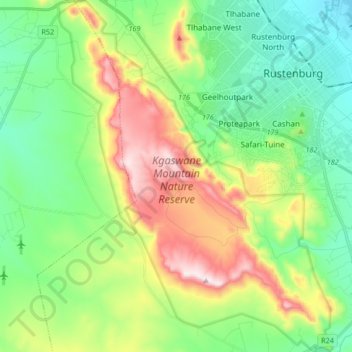
Nom : Carte topographique Kgaswane Mountain Nature Reserve, altitude, relief.
Altitude moyenne : 1 306 m
Altitude minimum : 1 112 m
Altitude maximum : 1 698 m
Autres cartes topographiques
Cliquez sur une carte pour visualiser sa topographie, son altitude et son relief.
Rustenburg Ward 9
RSA > North West > Rustenburg Local Municipality
Rustenburg Ward 9, Rustenburg Local Municipality, Bojanala Platinum District Municipality, North West, RSA
Altitude moyenne : 1 207 m
Olifantsnek Dam
RSA > North West > Rustenburg Local Municipality
Olifantsnek Dam, Rustenburg Local Municipality, Bojanala Platinum District Municipality, North West, RSA
Altitude moyenne : 1 246 m