
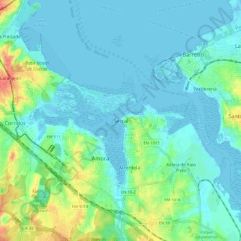
Carte topographique Seixal
Carte interactive
Cliquez sur la carte pour afficher l’altitude.
À propos de cette carte
Nom : Carte topographique Seixal, altitude, relief.
Altitude moyenne : 43 m
Altitude minimum : -3 m
Altitude maximum : 462 m
Although the municipal population continued to grow with development, after the 1970s there was a boom in the population, due to improvements in accessibility and mobility, principally due to public transport, its location to Lisbon and installation of economic activities within the territory. This growth transformed, in a short time, from a territory predominantly rural into an urban municipality, consisting of agglomerations of large dimensions focusing on various establishments and social centres. This growth resulted in the 1993 elevation of Seixal and Amora into cities, and the establishment of Corroios into the status of town.
Autres cartes topographiques
Cliquez sur une carte pour visualiser sa topographie, son altitude et son relief.
Alto do Moinho
Portugal > Setúbal > Seixal > Corroios
Alto do Moinho, Corroios, Seixal, Setúbal, 2855-719, Portugal
Altitude moyenne : 36 m